

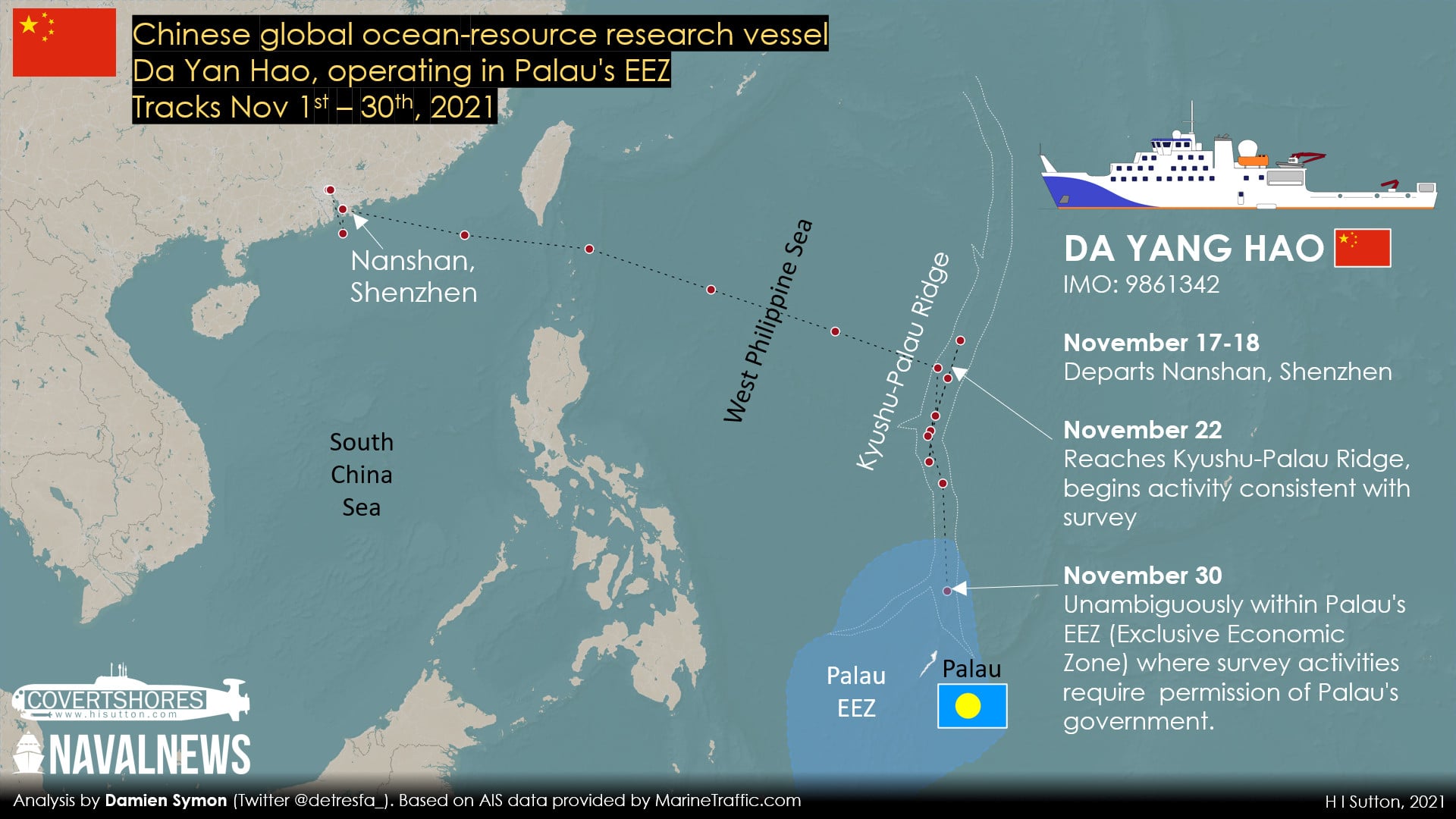
A Chinese government survey ship, Da Yang Hao, has been accused of illegal activities in Palau’s waters. Palau is a small island nation, strategically located between the Philippine Sea and the North Pacific. Using ship tracking data provided by MarineTraffic.com we can confirm that the Chinese vessel was operating in Palau’s Exclusive Economic Zone (EEZ).
Based on the vessel involved, the survey could relate to undersea hydrocarbon or mineral resources. Alternatively, it could be a sea-bottom mapping missions and gathering data on the waters for scientific purposes. The data could have a dual civilian and military use and is particularly relevant for submarine warfare. In any case it would need permission from Palau’s government to operate there.
In spite of its presence being challenged, the ship appears to have conducted its activity unimpeded. It was there for 5 days, from November 29 until December 4, 2021.
Local authorities raised their concerns, as reported by the Island Times on December 3. Palau’s Maritime Security and Fish & Wildlife Protection (DMSFWP) were keeping track of it, but had been unable to act. Palau requested assistance from the U.S. Coast Guard.
What The Data Says
Analysis of the AIS (Automated Identification System) data by Damien Symon, a geo-intelligence analyst, followed the vessels path. It appears to have reached its survey area in the West Philippine Sea around November 22. It then ran up and down an underwater feature known as the Kyushu-Palau Ridge. Based on the analysis, the ship had clearly entered Palau’s EEZ by November 30. It spent some time there, tracing the lines of significant underwater features, before returning north again.
The pattern of movement is indicative of sea floor survey. As is the fact that it followed a significant underwater feature, principally the Kyushu-Palau Ridge. Surveys of this nature require the permission of the country’s whose EEZ it is.
Additionally, all mining (and fishing) is banned in the waters where the Chinese ship was. It is part of Palau’s massive National Marine Sanctuary (PNMS) which covers 80% of its EEZ, roughly 200,000 square miles. The remaining 20% is set aside for domestic fishing. Tis uses traditional methods and only supplies local markets.
Da Yang Hao, China’s Strategic Survey Ship
Da Yang Hao is one of the most modern, and capable, of China’s ocean-going survey vessels. When it was launched in December 2018 it was considered China’s first ‘global ocean-resource research vessel’. It was designed by China’s 701 Research Institute and is operated by the Ministry of Natural Resources. This implies a role in the exploration of natural resources. But it is more versatile than that and boasts a large capacity for laboratories and equipment. The 98 meter long, 4,780 ton, ship has already been used in the Atlantic and South China Sea.
The same survey vessel was previously reported operating in the in the South China Sea in September. This took it inside the EEZ’s of Brunei, Malaysia, and the Philippines. It is unclear whether it had their permission.
Palau and other smaller countries in the region are less able to challenge the apparent unauthorized survey of their EEZ. Despite its strategic location, which could place it on the frontline of future naval actions, Palau is one of the few countries without any armed forces. Instead, it relies on the United States for protection, and there is a growing US presence on the islands.

The police service does operate two small patrol boats, but these were apparently unable to reach the Chinese ship due to the weather. In the past Palau has called on the U.S. Coast Guard, typically stationed on Guam, for assistance.
It has not been reported whether the US Coast Guard, or Palau’s own patrol boats, ever met with the survey ship. Or what caused the ship to subsequently return north. However, circumstantially, it appears that it simply completed its mission, seemingly uninhibited. The Island Times reported that it left of its own accord on December 4, after spending about 5 days in Palau’s waters.
The data gathered in these types of survey has relevance in undersea warfare, particularly for submarines. The Kyushu-Palau Ridge will be an important feature in submarine operations. And knowing its details may help China in this regard. The alternative explanation, that the survey was about natural resources, will not be more reassuring for Palau or other regional players.